Packrafting the North.
words :: Cameron Fenton
“I have to keep reminding myself this is what these boats are made for,” Nick joked as his packraft skidded across another set of sharp, shallow rocks.
Nick, Daphne and I had just started our descent of Black Wolf Creek. Known as Dı́ga Dezene Deé to the Sahtu Dene First Nation, the steep and frigid river lies deep in the backcountry of Nááts’įhch’oh National Park Reserve, NWT. Getting to the river is an adventure in itself, starting with a floatplane and then a few days paddling the Broken Skull River. From there, it’s a long hike up an untracked valley to Nááts’įhch’oh, a lake high in the Mackenzie Mountains. From those headwaters Black Wolf runs cold, clear and fast through 60 kilometres of some of the most remote whitewater in Canada before returning to the Broken Skull River. With just a handful of recorded descents, we had only vague beta: Class III-IV whitewater, broken up by a Class V canyon with a portage route previous groups had called “sketchy,” “exposed” and “heinous.”
We were about to find out for ourselves.

• • •
The adventure started four days earlier with a six-hour drive along the all-gravel Robert Campbell Highway to meet our float plane pilot at an air base, which was tucked into a protected bay on Finlayson Lake, a 16-km long lake east of Whitehorse.
Near the float plane dock, a sign erected by the Ross River Dena Council identifies Finlayson Lake as Legaenjoje, named for a legendary hunt. The sign is an apt reminder of the role Indigenous peoples played in the creation—and still play in the management—of both Nááts’įhch’oh National Park Reserve and its more famous southern neighbour, Nahanni National Park Reserve.
We flew in a brown and yellow 1957 De Havilland Beaver—which Kluane Airways has been using for decades to shuttle paddlers, hunters, Nahanni Park staff and Indigenous residents—toward the Yukon/NWT border and skimmed down into Divide Lake.

Set in a wide, glacier-carved valley high in the Mackenzie Mountains, Divide Lake’s Indigenous name, Ǫtaa Tu Fehto, translates to “bucket of water at the high point of land.” From the lake, water flows south into Divide Creek then into the Broken Skull River or Pı̨́ı̨́p’enéh łéetǫ́ǫ́ Deé.
Initially, Indigenous communities were skeptical of the Nahanni River becoming a park. Early discussions in the 1970s were rife with concerns about a park formalizing federal government ownership of lands and restricting use of traditional territory. Navigating this resistance meant the park was first only a narrow river corridor below Virginia Falls. The park was also given the Park Reserve designation which, according to Parks Canada, is for “an area that is managed like a national park but is subject to one or more Indigenous land claims.”

In 2009, the park expanded to cover more of the surrounding lands, with the Nááts’įhch’oh lands added in 2014 to protect the river’s headwaters. Both parks now operate under co-management agreements with the Indigenous nations whose traditional territory lies within them—the Sahtu Dene in Nááts’įhch’oh and the Dehcho in Nahanni.
Paddling out of Divide Lake was a quick education in this wild country. We looked down through crystal-clear water to see a caribou carcass beneath the surface. Whether felled by injury, illness or a predator, the massive ungulate’s eye stared up at us from its watery resting place as we crossed from the lake into the flowing waters of Divide Creek.
Swift current carried us down the upper Broken Skull, riding glass-clear water through a series of small, rocky rapids. All around us, towering green and grey peaks—the northeastern tip of the Rocky Mountain range—scraped at the sky. A few scrubby trees flanked the river corridor. From our campsites, we carried light daypacks up onto endless ridgelines. From a high vantage, the landscape seemed to stretch on forever. We spotted black bears, caribou, moose and enough unnamed river valleys to sustain a lifetime of exploration.

Swift current carried us down the upper Broken Skull, riding glass-clear water through a series of small, rocky rapids. All around us, towering green and grey peaks—the northeastern tip of the Rocky Mountain range—scraped at the sky.


After three days paddling and hiking along the Broken Skull, we loaded our gear into backpacks and started trekking up a wide drainage called Shúhzhıé káı̨lı̨—the creek flowing out of the mountain. On maps, it’s labeled “Grizzly Bear Creek.” As we stepped carefully across cobbled riverbeds and followed faint game trails, we echoed loud calls of “Hey bear!” to warn any namesake bruins of our approach.
A little more than halfway up the valley, we came upon a bend in the creek where massive, pale-yellow rock formations rose from the riverbank. Called tufa mounds, these unique formations are piles of calcium carbonate—the same material found in coral—that has precipitated to the surface from a vast network of underground waterways. In this valley, the tufa mounds also marked the site of Sadéé Shúh Gaǫfáá, Sunlight Mountain Hot Spring.

Many hot springs like this exist throughout the Nahanni country, fueling an 1800s myth that a tropical valley lay hidden in the area. Stories from prospectors, explorers and trappers told tall tales of a valley that stayed snow-free all winter, where crops flourished year-round and giant, prehistoric beasts still roamed the lands.
Sadly, we didn’t see any dinosaurs or mammoths, but the hot-spring pools, nestled in a meadow of grass and wildflowers, were a welcome reprieve from our heavy packs. We sprinkled black tea leaves into the waters before sliding in. (Parks Canada, in accordance with local Indigenous traditions, suggests sprinkling an offering of either tobacco or tea leaves before using the springs.)
Related content from ML:
After a long soak we headed for the pass at the head of the valley, traversing the creek’s headwaters: a small collection of milky-blue pools, teeming with Arctic grayling.
Over the pass lay a massive lake with a pair of loons floating amidst the splashes and surface ripples of jumping fish. As we poured boiling water over dehydrated meals, an early evening storm blew through the valley and clouds shrouded the sawback ridgeline that gives the lake its name, Nionep’en eɂTué, or “prehistoric backbone.”
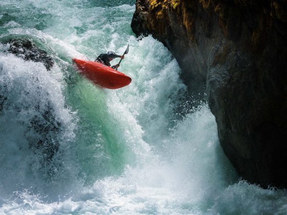
The next morning we inflated our packrafts and paddled into Black Wolf Creek, reclining atop our boats through the lazy current then strapping on helmets when the water picked up momentum. We plunged into a narrow slot of black volcanic rock, home to the shallows that had Nick questioning the structural integrity of our packrafts. Eventually, an unnamed creek joined from the left and bolstered the flow.
We plunged into a narrow slot of black volcanic rock, home to the shallows that had Nick questioning the structural integrity of our packrafts.
Black, grey and orange mountains beckoned us downstream. Around a bend in the river, a lone caribou appeared, its mottled fur giving the ominous sense of an animal abandoned by its herd. It watched us skittishly as our brightly coloured flotilla bobbed past. Downstream, we could see the oncoming walls of a canyon and hear the deep rumble of whitewater.
The first canyon was a series of short drops flanked by sun-bleached limestone boulders. We scrambled along the shore for a quick scout, determined it was good to go and splashed our way through a series of crashing waves and small recirculating holes. Our packrafts handled like the love child of a whitewater kayak and a pool toy, plenty capable in the rapids, but still an inflatable without clear edges or a rigid hull.

The rest of the day flew by in a happy blur of easy whitewater and bigger, boulder-strewn rapids. At one such rapid, Nick signalled to paddle hard right, just before disappearing over a horizon line. I followed and looked left into the gaping maw of one of the biggest holes I had ever seen. Nick was stopped in an eddy just downstream.
“Well, that would have sucked,” he deadpanned, coining the hole a certified “packraft eater” for anyone unlucky enough to paddle into it.
By early evening, we arrived at the crux of the river, a tight canyon guarded by a massive, boulder-choked, Class V rapid. We knew an exposed portage across a crumbling scree slope awaited us and decided to camp and tackle it in the morning.
That night, the roar of the rapids echoed from the canyon up to my tent. The midnight sun barely dipped below the peaks that towered above the river, casting the valley in a pale twilight. What little sleep I got was fitful at best. We ferried across the river in the morning and found a more inviting portage on the left bank. By mid-morning, we were back on the river.
After a series of straightforward rapids, the river disappeared around a left-hand bend. Now in the lead, I slowed down and turned across the current, straining to make out the rapid hidden below the horizon line ahead of me. As I mentally pieced together my line, I heard the rubbery grinding squeak of my boat hitting a rock just beneath the surface and, lurching forward, suddenly flipped into the freezing water.
I came out of my boat almost instantly. Grabbing hold of my gear, I fought to control my breathing in the frigid water. I tried to flip my boat for a self-rescue but was in the rapid before I had a chance. I braced myself for a rough ride.

The rapid split around a massive rock, tossing me to the right and straining my grip on the boat and paddle. I flipped around in the current like a fish spent from fighting a determined angler, then finally managed to splash-swim into a small eddy. After taking stock of my gear and confirming all limbs still intact, I flipped my boat, dumped out the excess water and looked back upstream. Nick and Daphne paddled behind me through the best, and last, real rapid of the run.
The whitewater eased as the valley opened below us. Black tree trunks, tall swaying grass and electric-purple fireweed were all that was left of a wildfire that had scorched this part of the valley. We stopped on a cobbled gravel bar for lunch, then passed through one more idyllic canyon, the sun glinting off azure-blue water and pale limestone walls.
I flipped around in the current like a fish spent from fighting a determined angler, then finally managed to splash-swim into a small eddy.
By mid-afternoon, Black Wolf Creek spat us out back onto the Broken Skull. We paddled a few kilometres and camped on a wide sandy beach at the confluence with the silt-laden waters of the South Nahanni. The sun was still high and hot—mid-July well north of the 60th parallel—when we all retired to our tents. We still had a few days left on our trip, but from here down there was little in the way of hazards or whitewater.
I lay awake thinking about my swim. What started as frustration slowly gave way to appreciation. I already knew I wanted to spend more time in the Nahanni country, exploring the seemingly endless array of rivers and ridges that we had already passed on our trip. I felt drawn back to Black Wolf and to the rapid that had gotten the better of me. I pulled out my journal and made a note. Unfinished business on Black Wolf. I need to run that last rapid properly. I fell asleep—tired, sore and happy.

Check the ML Podcast!